 Want to vacation memorable? Such an opportunity will provide you a bicycle trip through the archipelago of Turku in Finland.
General information on the archipelago of Turku
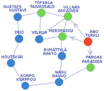
In the Turku archipelago comprises more than 20.000 islands. Tourism for the island became an important activity. You are waiting for the whole cottage villages, hotels with restaurants, family-run guesthouse and pleasure boats. Fishermen and farmers take care of visitors and will enjoy gourmet fresh seafood from clean waters. You can also enjoy crafts masters of craft cases, such as in a potter's shop or even purchase a souvenir favorite crafts.Route around the ring of the archipelago of Turku - Rengastie
The total route length of 250 kilometers.
Turku for many traveling by bicycle around the ring is an archipelago as the starting and end point. With dozens and dozens of bridges, ferries will meet on the way a cyclist or a motorist, traveling from island to island and admiring the unique natural beauty of the archipelago.
From the center of Turku in Finland to the direction of Kaarina paved bike path. Its length is about 10 km. In Kaarina you turn on the road leading to the archipelago to the cities and Parainen Korppoo, and the mainland will remain behind you as soon as the center of the bridge you will pass Kaarina Kuusisto.
In Kuusisto You will be able to roll to the ruins of an ancient fortress, which the survey did not take long, because the distance to it only 13 miles. Leads to the ruins of a pointer on the way to the archipelago of 500 meters from the bridge towards the city Kuusisto Parainen.1 site Turku - Parainen, 23 km
Parainen - Gates of the archipelago. Parainen - the only city in Finland, surrounded on all sides by water. Idyllic and at the same time, a vibrant city known for, above all, its limestone and these cakes from Paraynena. In this town you can meet famous artists coming to Parainen the world famous music festival Rowlit in the City or to have become popular days of organ music.Route description
The border between the towns of Kaarina and Parainen passes exactly in the middle of an impressive suspension bridge across the Strait Kirjalansalmi. The road leads you to the archipelago of islands on the main island Kirjala Paraynena Alon, you follow up the circular motion, where a pile of white limestone rocks laid out like a white sail. At this point turn left to downtown Parainen, where you'll find everything you need for yourself, including reference travel agency with information on the archipelago.
From the road forks Lielahti, not reaching five miles from the center, there is a pointer to the farm Tammiluoto, known for its winemaking. The road runs through the picturesque countryside past built in 1500-ies of the fortress. Additional "hook" on a wine farm is 24 km.
An alternative route from downtown Parainen can get expensive Skrabbolentie, leading to the biggest in Scandinavia career development limestone open pit. The observation deck in the courtyard of the museum career.
From Parainen already started the ring road to the archipelago. At 10 kilometers from the center of the bridge Sattmark is a hut built sailor-1700's or sailor's tavern. The cafe is open from May to September. Here you will find additional information on the nature trail Lenholmen and hiking routes in Sattmark with an instructor.
Before Lillmalo on your way to meet the first ferry. Before him, from the center Parainen - 17 km. Yellow Ferry Road Survey of Finland are free and go on schedule. The inhabitants of the archipelago, and local officials have, for obvious reasons, of course, the right of way on the ferry. However, cyclists can get on the ferry without any queues.2 Plot Parainen - Nauvo, about 33 km
In addition to existing in the archipelago in Nauvo two unique large islands, there are still 3,000 small islands and reefs.Route description
The trip by ferry from Lillmalo in Nauvo, Prostvik lasts ten minutes. After 15 km you in the ancient village church Nauvo. But on the way you have come across two bridges, passing on that, especially through Norrstromm, you'll enjoy the open before you natural beauty.
Near the most popular holiday haven in the heart of the village are hotels, restaurants and other important and interesting tourist sites. Pay only, please note that there is a last one on the way automated teller machine, the following will only Kustavi.
If you prefer, you can reduce your route if you use the new ferry Maritime Administration of Finland on the island of Seil Nauvo through the port Hanka, Rymattyla (will be "cut" section of ring road on the archipelago of Turku - Nauvo - Rymattyla - Turku length of almost 110 km). From May to September, as walking boat m / s Linta. Island Seili, rich with its horror stories, too, is a very interesting site for excursions.
Another goal of the day trips is the island Gullkrona, where you get to the ferry m / s Fiskolla from both Prostvik (village 100 meters from the ferry terminal Parainen - Nauvo), and from the village Kirjais, on the south side of the main island Nauvo.
In general, this section of the ring road to the village Parnais archipelago is about 15 km. If you want to avoid traffic on a bicycle on a busy highway, you have the opportunity to go in the same direction on a dirt road on Storlandet. In this case, you should turn right to the center once after Nauvo pointer to Mielis.
From Parnais short five-minute ferry ride to the island Korppo (Retais), again on a yellow free ferry service road in Finland.3 phase Nauvo - Korppoo, 27 km
Korppoo located in the center of the archipelago. Only one tenth of the community is landlocked, and the rest - water. Church in Korppoo constructed from local rubble still in 1200's. The famous islands of the archipelago outside Jurmo Uto and includes a community Korppoo. From the island Galtby, Korppoo ferries and the Åland Islands.Route description
Retais length of the ring road to the fork in Galtby is 7 km. If you prefer, you can call in center Korppoo and continue on the archipelago. From the center of the road leads on to the lookout tower on the island Rumar (7 km) or to the village Korpostrom (also 7 km).
His trip on the route of the ring road from the village Galtby, Korppoo to the port on the island Kuttuis Houtskar you continue on the yellow road ferry services in Finland. You can also go to the island Norrskata, where a ferry and from Galtby. In Norrskata and you can dine and spend the night. Ferries that ply between Korppoo and Houtskar, differ from the previous two, they do not have a strict schedule, the schedule will be in place. The biggest traffic jams in the morning and evening ferries - it is here, that's why Decide where you will sleep better - or at Korppoo Houtskar?4 plot Korppoo - Houtskar, 25 km
Houtskari - The only community in the archipelago, where they speak only in Swedish. Landscape Houtskar - this alternation of wooded islands and rocky outer reef. Recently, on a boat you can take a guided tour on the island Jungfruskar, a former naval base, where access was previously unavailable. A group of islands Jungfruskar - one of the most beautiful and mysterious in the Archipelago National Park.Route description
From Korppoo you arrive by ferry to Kittuis. Continuing the journey along the ring road of the archipelago from one island to another island group Houtskar ferries Kivimo Mossala and offer short and free voyages. Throughout the route Houtskar - 27 km.
Landscape village Hyppeis so beautiful that it is worth even deviate from the route (distance in both ends of approximately 13 km). In the village of Jarvis You can climb the observation tower where available, which offers magnificent views of the archipelago.
The longest sea journey along the route of the ring road on the island in Mossala Inio. Ship Maritime Administration of Finland m / s Inimoon take on board 190 passengers. Do you have an opportunity during the trip for nearly an hour to admire the beauty of the harsh nature of the archipelago on board the ship or from a window cafe. This trip is paid, although the tariffs set by the Administration shipping low.5 plot Houtskari - Inio, 25 km
Inio - small community with a population of about 250 people, but with a large coastline of 700 kilometers. Island Inio - itself already vista, but you can still visit the church of Sofia Wilhelmina, go for a walk in the old picturesque village or to go deep into the forest, as well as to visit a windmill and sawmill plant Aselholm. In Inio a local radio station FM 99 MHz, introducing travelers during the summer with interesting information and news.Route description
From Mossala ferry arrives in the port Inio Dalen, who is on an island Norrby, where there is a church village, whose inhabitants are offered the necessary tourist services. The ferry will take you to the island Keistio, where there is a store, marina and guest cottages. On the island Inio you find such a large number of proposals accommodation with breakfast and other services for travelers, as in any other community of the archipelago.
Norrby from a small segment of the path along the ring road on the island of the archipelago and Jumo Kannvik you swim on a free ferry (Skagen). The total length of the site on the island Inio is 8 km. In Aselholm you get on the ship m / s Jurmo II as of Norrby, and from Jumo. If we continue the trip to Laupunen, Kustavi, the port Heponiemi the ship m / s Aurora, it will be a second toll sea journey.6 plot Inio - Kustavi, 13 km
His name Kustavi received on behalf of the Swedish King Gustav III, who founded the church community on the Finnish coast of the archipelago. The story of a wooden cross Kustavi church dates from the year 1783. Beautiful ship models show appreciation of local sea dogs past their native and beloved community. Lighthouse Isokari - the most popular place of pilgrimage. In connection with the publication of a book of local writer Volter Kilvi «Kirkolle» was developed in 1999 on the occasion of his birthday for those interested in culture edge themed guided tour.Route description
Continuing his way out of Laupunen towards Turku on the highway Kustavintie, turn right to Taivassalo. The length of the route from Laupunen, Kustavi to Turku is about 83 km. Turning to the same intersection on the left will take you to the center Kustavi. Quieter roads to the center (2,5 km) leads from the ferry terminal Parattula.
From the center can continue their journey to the island Vuosnais, to which the free ferry at hand. On the island there is a guest Vuosnais port, outside the store and other services, but most interesting is that here you can go directly to the Aland Islands, a port Maarianhamina. The route passes through the communities of Brandon and Kumlingen by ferry companies Alandstrafikenin. Alternatively, you can use the bus service between the cities Kustavi - Turku.7 plot Kustavi - Taivassalo, 17 km
Taivassalo. When first introduced in 1638 between Turku and Stockholm was organized by e-mail message used to do this already formed during the Middle Ages, the route. At a transit bank Helsinginranta in Taivasalo, where sea-post road was coming before the entire mail, survived to this day parts of the pier. Postal route has now become the cycling tourist destination.
Currently, every year the most popular event in early July Taivassalo are the days catch of herring and sprat Fair. Beautiful landmark of red granite, installed in front of a cafe Merituuli, is a natural symbol Taivasalo.
One of the longest bridge in Finland was built in 1982 across the Strait Kaitainen. Old stone bridge across the Strait Muntinsalmi, built in 19 century of boulders, is part of the State Museum of roads.Route description
Arriving on the ring road in the archipelago Taivasalo, you can choose either of two routes: to go by boat from Hakkenpaa in Teersalo, Velkua or on the road to Askainen. From the church in Taivasalo road leads to Hakkenpaa, a distance of 8 km. From Hakkenpaa a ship m / s Kivimo takes you Velkua. In Askainen takes you on the road Kustavintie (N 192), driving along the 20 miles which should turn right to the center Askainen. From Askainen further fall into Merimasku. It makes sense to also visit the lively Velkua.8 plot Taivassalo - Askainen, 29 km
Askainen Finnish Field Marshal Mannerheim was born at the castle estate Louhisaari, built by a Finnish gentleman Herman Fleming in 1655. In Askainen Fleming also built a stone church from local boulders. In the old estates of the region still feels shine past tenses. In Askainen perfect conditions for enjoying the outdoors and the sea. Beautiful beach Pikisaari, feast day Livonsaari, smoked fish markets or well-known all over the country market cucumbers - is a weighty argument in favor of the visiting Askainen.Route description
After Velkua, after a couple of miles, as the cross border communities Askainen, you get to the island Livonsaari. After 16 kilometers to the intersection and to get into Askainen, turn left. After four kilometers markers will appear in the center Askainen and the famous castle Louhisaari. From the church to the castle is two kilometers green corridor.
If you make another decision - to go out Taivasalo on the road on the north side Mietoistenlahti, you should turn right Askainen after 20 kilometers. Driving in these places, do not miss the opportunity to follow the signs to call the house Mietoistenlahti nature and learn about the most valuable species of birds at bay.9 plot Askainen - Merimasku, 13 km
Merimasku - is a small hub, leading to the communities north of the archipelago: You can come here from either side of the light and suitability to continue the trip as well. In the scorching heat of summer you can cool off with a swim at the beaches or Apajanrannta Sannainen, well, and still later, in summer or autumn you will rejoice myself picking berries or mushrooms, which are very rich in local forests.Route description
If you are traveling north on the road, then get into the church for a new village, built in 2003, the bridge. From Velkua road will lead you through the picturesque natural scenery Livonsaari and oak groves Lempisaari.
After passing the church village, four kilometers to the intersection where turning left takes you through the Naantali in Turku, or turning right, you can once again return to Rymattyla. If the route goes in the direction of Turku, we recommend that you make a halt at the bridge Sarkansalmi, boasting magnificent views of the inner archipelago. On the way to Turku your way will lie through town Naantali, with its famous island of Mumm-Troll restaurants and idyllic old city.
No comments:
Post a Comment